A 150km pipeline will bring water to villages and cattle ranches to Hakskeen Pan border.
The Bloodhound project has been working for the past three years at Hakskeen Pan and in the surrounding communities because this is where the team will be testing a supersonic car in 2015 and 2016, chasing a new land speed record over 1600km/h.
Richard Noble, Director of Bloodhound, said they realized there would not be enough water when the team will be there. "We expect up to 10,000 people to be there." he said.
The team went to the Northern Cape government, Mier municipality and the Department of Water Affairs and Sanitation to talk about the water situation. The plan now is for water to supply 60,000 people at the time of the event, as well as the residents of the area.
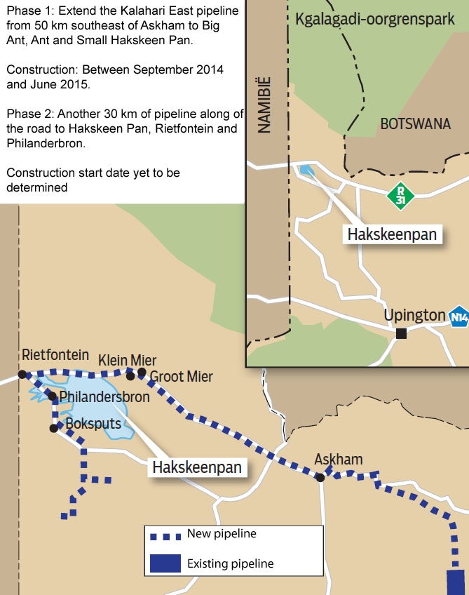 The existing Kalahari East pipeline will now be extended in two phases. The first will bring water to Askham , Big Ant, Little Ant and Hakskeen Pan and 130 small farms in the area brings. The preliminary phase will start in September this year and will be completed in June 2015.
In the second phase, the pipeline will reach Rietfontein and Philanderbron. This will be done after 2015.
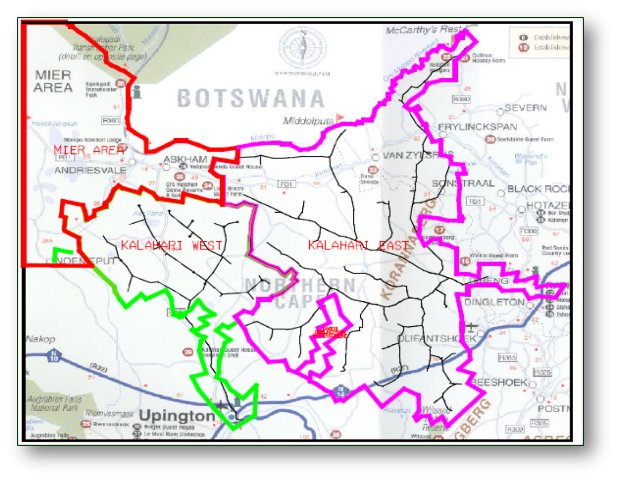
Dr. Rian Titus, a hydro-geologist from GWI Consulting which is involved in the project, said Mier municipality includes Noenieput, Askham, Big Ant, Little Ant, Loubos, Rietfontein, Philandersbos, Andriesvale Welcome and about 130 small cattle farms .
The pipeline will eventually bring water to everyone that currently sees very little rainfall. Just under 10,000 people live in the area.
The pipeline will carry about 23 litres per second, 24 hours a day.
During the past three years, 310 people from the area involved in the Bloodhound project by picking up thousands of tons of rocks on Hakskeen Pan.
MTN also have erected five mobile phone towers, each 70 metres high, so that the world can follow the record attempt via the three video feeds and 300 data channels.. "We hope that many people will benefit from the water and the educational projects and opportunities that Bloodhound brings" Richard Noble said.
(Translated from Die Burger, 10th June 2014)
Background information
The Mier municipal area covers more than one million hectares and includes a number of small towns ( Noenieput,Askham, Groot Mier, Klein Mier, Loubos, Rietfontein, Phillandersbos, Andriesvale en Welkom) and approximately 130 mostly small stock farms.
Sustainable water provision will have a significant positive impact on the welfare of the Mier communities and the economy of the area. Access to adequate water resources is currently a major constraint to sustainable socio-economic development within the Mier Local Municipality.
Improved water services provision to the Mier Local Municipality area will result in the following:
- Significant temporary job creation during the phased execution of the pipeline project over several years depending on funding arrangements.
- Improved basic services and more sustainable living conditions in the small towns throughout the Mier Local Municipal area.
- Improved agriculture output and higher stock production.
- Increases in property values.
- A significant number of permanent jobs as a varied and sustainable tourism industry grows.
The North Western extension of the existing Kalahari-East Water Supply Scheme is the most feasible option to supply water at an adequate quantity and quality to the North-Western part of the Kalahari region, i.e. the jurisdictional area of the Mier Local Municipality (including towns, small-scale / subsistence and commercial farms as well as the Kalahari Trans Frontier Park) and beyond. The feasibility and socio-economic opportunities for the North Western extension of the Kalahari-East Water Supply Scheme have been assessed over a number of years and two feasibility study have been completed in 2005 to 2011 respectively. The social and economic upliftment of the Mier communities are championed, through water related projects, by the Department of Water and Sanitation as well as the Northern Cape Provincial Government and Mier Local Municipality.
Hakskeen Pan is earmarked to host a number of major, international (eg. Bloodhound SSC Project) and regional events over the next few years. Such events will attract large numbers of visitors to the Mier area that will require varied services and accommodation in the area.
1) From where to where will the existing pipeline go?
Phase 1 of the north-western extension of the existing Kalahari-East Water Supply Scheme, planned for completion in mid 2015, will extent from approximately 50 km south east of the town of Askham to Andriesvale (SAN community), Groot and Klein Mier, Riefontein to Philandersbron. This phase of the project will also supply some small farms in the vicinity of the pipeline.
2) Where is the existing pipeline currently?
The existing Kalahari East Water Supply Scheme was completed in 1994 and serves 278 farms covering 1 480 624 hectares of land with a pipeline length of more than 1200 kilometres. The scheme, operated by the Kalahari East Water Users Association, provides water mainly to commercial stock farms for agriculture as well as for domestic purposes (on these farms).
3) What length of new pipeline must be laid down?
Approximately 150 km of pipeline will be completed in two sub-phases for the initial pipeline development:
- Phase 1 A – Construction of the first 120 km pipeline from the Kalahari-East connection point (50km south-east of the town of Askham) to the towns of Groot Mier, Klein Mier and Hakskeen Pan. (including a reservoir in the Mier area)
- Phase 1B –Construction of a 30 km of pipeline next to the tar road extending from Hakskeen Pan to the towns of Rietfontein and Phillandersbron.
The commencement and execution of the initial pipeline development phases (planned for September 2014 to June 2015) depend on the completion of the EIA process.
Subsequent phases of pipeline development (beyond 2015) will supply smaller farms to the north and commercial farms to the south of the Mier area, 3 border control posts, Kalahari Gemsbok Park and possibly small towns within Botswana.
4) Which areas currently have water and which areas will have water after the extra parts of the pipeline are completed?
The existing Kalahari East Water Supply Scheme was completed in 1994 and serves 278 farms covering 1 480 624 hectares of land with a pipeline length of more than 1200 kilometres. The scheme, operated by the Kalahari East Water Users Association, provides water mainly to large, commercial stock farms for agriculture as well as for domestic purposes (on these farms) to the south of the Mier Local Municipal area. The current utilization of the scheme is 75 L/s.
The Kalahari East pipeline is designed to provide 23 l/s to the proposed north-western extension of the existing Kalahari-East Water Supply Scheme with planned water allocations as follows:
- Water demand for towns in the Mier area is approximately 11 l/s.
- Water demand for small stock farms within Mier area, with a total area of approximately 340 578 hectares, is 10.24 l/s.
- Water demand for commercial farms within and north of the Mier area, with a total area of approximately 266 670 hectares, is 9 l/s.
- Water demand for 3 border control posts is approximately 2 l/s.
- Water demand for Kalahari Gemsbok Park of 1.7 l/s.
- Possible supply to small Botswana towns close to the border with South Africa.
The total water demand exceeds the potential supply of 23 l/s but can be supplemented by sustainably developing groundwater resources (where available) along the planned pipeline route. The groundwater resource within the Rietfontein area can be utilized as a permanent supplement to the Kalahari-East Water Supply pipe line during the summer months.
5) How much water will be delivered to the area (i.e. Mier Local Municipality and further north)?. And how many people live in the area?
The Kalahari East pipeline is designed to provide 23 l/s to the proposed north-western extension (i.e. to the Mier Local Municipal area and beyond) of the existing Kalahari-East Water Supply Scheme. All water supply schemes are designed to supply water at a constant flow rate over 24 hours to all end users.
Less than 10 000 people reside in the Mier Local Muncipality area and are equally distributed between those living in the small towns and those living on the small stock farms.
6) Will the pipeline be underground?
The pipeline will be placed underground and predominantly within the road reserve to reduce potential environmental impacts. Major infrastructure development in terms of electricity supply and roads have taken place over the past 20 years in the Mier area. The road & electrical supply infrastructure determined the preliminary design of the water supply components as well as the operation and maintenance aspects of the north-western extension of the existing Kalahari-East Water Supply Scheme.
7) Where does the water come from? What is the source?
Water is pumped from the Sishen mine into the Vaal Gamagara pipeline that supplies water to the Kalahari East Water Supply Scheme at a maximum rate of 103 l/s. The current utilization of the Kalahari East Water Supply Scheme is 80 l/s while 23 l/s is earmarked for the planned north-western extension of the existing Kalahari-East Water Supply Scheme.